CUBEX
High Altitude Balloon Payload
Flight Data
Flight Story
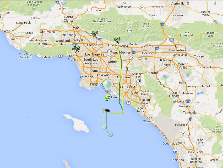
On May 24th,2014 CUBEX-1 launched at 20:00 UTC from Monrovia,CA. The payload consisted of CUBEX-1 and a Leo Bodnar B tracker. CUBEX-1 transmitted SSDV images (JPEG) at 320x240 as well as tracking telemetry during its flight on 434.460Mhz (300baud ASCII 8n2). The B tracker was an APRS beacon. The payloads reached a maximum altitude of 33698m (110,560ft) and transmitted down 50 images during flight. After burst, the aprs tracker stopped and CUBEX-1 lost GPS, however, it continued to transmit SSDV images. As predicted, the estimated landing zone is the pacific ocean.
Images


Flight Path
Launch Day Photos
Photos by dmertl: https://www.flickr.com/photos/dmertl/sets/72157644453015680/
People who made this possible:
Philip Heron: https://github.com/fsphil
Anthony Stirk: http://ava.upuaut.net/store/
Leo Bodnar: http://leobodnar.com/
Flying Apple Space Technologies: http://flyapple.org/
Layerone: http://layerone.org
Davo, t00lbox, pLarceny, stealth, Blakangel, JN
K6WCC, KK6FAN
UCLA (Kyle Colton, Ryan Caron, W6YRA)
Live
Images
Image Telemetry Status: GOOD
Tracking
Tracking Telemetry Status: GOOD
Brought to you by: ssdv.habhub.org
For more information about SSDV, visit: http://ukhas.org.uk/guides:ssdv
For more information about SSDV, visit: http://ukhas.org.uk/guides:ssdv
Brought to you by: http://habitat.habhub.org/mobile-tracker/
For more information about UKHAS, visit: http://ukhas.org.uk/
For more information about UKHAS, visit: http://ukhas.org.uk/
Event
What?
CUBEX 1
High-Altitude Balloon (HAB) launch
Where?
Layerone Conference
(34.139157, -118.018872)
Monrovia, CA
Latitude: 34N 8' 20"
Longitude: 118W 1' 8"
When?
Saturday
May 24th, 2014
12:00pm PST
20:00 UTC
Payload Info

Payload Webpage: CUBEX-1
Frequency: 434.460Mhz
Modulation: FSK (Frequency Shift Keying) - (USB) Upper SideBand
Encoding: RTTY (Radioteletype) - 8N2 ASCII
Baud Rate: 300 baud
Shift: 450Hz
Station Setup
What do you need?
1) Radio
Pick one:
a) +
b) +
c) +
2) Antenna
Pick one:
a)
b)
c)
3) Computer
Any computer with an audio or usb port will do. Mac, Windows, or Linux.
4) Software
(Only if you have a HackRF or USB RTL)
Hourly Predictor